![]()
This blog was written by MapsPeople, a Liveli technology partner.
Five questions we always ask you about your project
Software solutions are an investment for your company. Whatever the cost, they should add value, cover your needs, and help you reach your goals.
The indoor navigation industry is growing and venues around the world have discovered the need for and benefits of indoor wayfinding. However, as the technology is rather new, many are investing in this kind of software for the first time.
To make the process as easy as possible for you, we’ve made a list of five questions we always ask you about your indoor navigation project. This way, you know what to consider before meeting with us.
#1. What is the use case?
MapsIndoors is not a solution - it’s a platform for your solution. A platform that can easily be combined with a great number of third party systems, so you get the solution that meets your specific requirements and needs.
Depending on your project, we’ll ask you
- What’s the purpose of using MapsIndoors?
- Who will benefit from the solution?
- Who are the stakeholders in the project?
- What do you want to achieve or solve with MapsIndoors?
- Do you have any specific requirements?
- What’s the timeline for your project?
Every building is different, but we have years of experience designing and developing indoor navigation solutions together with our customers. So, tell us about your needs and challenges and we’ll share our experiences, ideas, and best practices with you.
#2. Tell us about the area you need mapped
MapsIndoors is built to fit all industry needs and we can help you map your venue no matter how complex it is. At this stage of the process we just need to know the basics about the area, so we can, figuratively speaking, paint a picture of your building(s).
- How many square feet/meters?
- How many buildings?
- How many locations?
#3. Do you have card drawings?
To map your venue we need data, such as CAD drawings, room identification information, or the like. We can map your buildings from almost any format, but honestly, some formats are more time consuming than others. CAD drawings and DWG files are the fastest ones to digitize, so often we’ll ask you if you can provide these.
#4. Our App or yours?
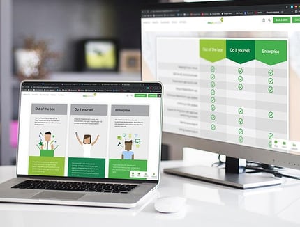
To make it easier for you, we've created three different packages: Out of the Box, Do It Yourself and Enterprise.
Out of the Box is the perfect choice for companies that need an accurate and user-friendly indoor map without all the additions. We’ll set up the look and feel parameters we can without further development and you’ll be ready to navigate in no time.
Do it yourself is our most popular package. A perfect match for companies that want to integrate MapsIndoors in their own environment and apps. We'll provide initial startup support and you'll do the rest.
If you need specific features and customized development, Enterprise is the solution for you. We’ll engage in discussions and develop specific features and do all the hard work for you.
The price of each package depends on the size of your venue and your requirements.

#5. Do you need positioning?
By pairing your indoor navigation solution with an indoor positioning system (IPS) you unlock a long row of benefits that go way beyond wayfinding - but do you really need this?
There are many advantages of IPS, such as improved user-friendliness and user experience, insights, and location-based marketing, but IPS also cost about 3-4 times more than indoor navigation and requires hardware that needs fingerprinting and maintenance. If you don’t have the budget for a full-scale integrated indoor navigation solution, MapsIndoors is the easiest step 1 that you can take to provide employees and visitors with wayfinding. Once you have the budget, you can add positioning or other 3rd party integrations. With MapsIndoors you don’t need to do everything at the same time - keep it simple and scalable.
Reach out to us if you want to discuss your project further with a Liveli team member.
This blog was written by Malou Damgaard and repurposed with permission from MapsPeople.
Back To News Stories